
© Dr. Klaus Dierks 2004: Photo: Rongbuk Gompa: Chomolungma - Mount Everest North Face Base Camp
PHOTO DOCUMENTATION: TIBET-EXPEDITION'1997
Klaus Dierks
© Dr. Klaus Dierks 2004-2005
© Dr. Klaus Dierks 2004: Photo: Rongbuk Gompa: Chomolungma -
Mount Everest North Face Base Camp

Copyright: Lonely Planet Publications, 3rd Edition, 1995
In March 1959 fled the Dalai Lama Tibet due to the outbreak of the Resistance War of the Tibetan People against the Peoples Republic of China. Some weeks later I was on a trekking tour in northern Sikkim, without any permit and authority from the Indian Administration in Sikkim. My equipment was minimal and my resources and mountaineering experience more than restricted. My negligence can only be excused by my age of 23. In the vicinity of Lachen I was taken prisoner by a Chinese patrol. During 1959 the Chinese occupied some border areas in Sikkim and other parts of the Indian Himalaya. This was the ignition point of the Chinese - Indian border war in 1960 to 1962. The Chinese soldiers regarded me as an Imperialistic agent and forced me to accompany them to Tibet. This would in all probably meant my death sentence. Fortunately we experienced a terrible snow storm while crossing the border pass between Sikkim and Tibet. This blizzard saved my life. I could escape the Chinese soldiers. But nearly died of exhaustion without proper food and shelter. Some Tibetan nomads rescued me and took me secretly into Tibet into the vicinity of Kampa Dzong which was not occupied by the Chinese at this time. I experienced the still old Tibet culture and life as it existed before the Chinese marched into Tibet in 1950. The same nomads brought me safely back into Sikkim and India where I was able to report to the Indian Government what I had experienced. I was probably the first eye witness who had seen that the Chinese really had started the occupation of some Himalaya border areas south of the water shed which forms in many parts of the Himalayas the Sino-Indian border. My saga was never published in English but is only available in German: "STATT EINER EINLEITUNG - FLUCHT NACH TIBET".
It was a life long dream to visit the areas of my 1959 adventure again. When in 1990 I was elected as Member of the first independent Parliament of the Republic of Namibia and appointed as a minister of the Namibian government I was able to start working to make my dream to become a reality. In the mean time I had been to many trekking and mountaineering expeditions in many parts of the Himalaya and Karakoram. Due to the fact that for many decades there was a very close relationship between SWAPO of Namibia and the Peoples Republic of Namibia, a special permit with authorisation of the Chinese Prime Minister was granted that I was able to visit the still closed border areas between Tibet and Sikkim and other parts of Tibet which were already open to mountaineers and tourists in 1997.
The following photo documentation gives an impression what I had experienced in 1997 - and again on the Sikkim side of the Tibetan border in 2000. The expedition route took us (my wife Karen Dierks, nče Von Bremen and myself) from the capital of Nepal Kathmandu to the Tibetan frontier at Zangmu and from there to the Tibetan high plateau which we reached at Nyalam. We crossed the first pass of more than 5 000 m, the Lalung La. From there we travelled via Gutsuo to Tingri Shekar, which was the point of entry by the British expeditions in the 1920s and 1930s to the Mount Everest - Chomolungma north face. We visited the Chomolungma Gompa (monastery) of Rongbuk and the Mount Everest base camp. From there we went over some high passes to the old Tibetan Buddhist town of the Sakya order, Sakya. From Sakya we left the normal tourist paths and entered the "forbidden territory at the north eastern of Nepal and the northern border of Sikkim. Probably we have been the first westerners which were officially allowed to visit these areas since the last British Everest Expedition in 1938. We took our route via Dingyye, Kutschi to Rongxar, from there via Langma, Mukub Gompa, Ne Gompa to Kampa Dzong. From Kampa Dzong we went via some unnamed more than 5 000 m high passes to the Bhutanese border at the Bam Tso (Lake). From Gala we went back in "open" territory and travelled via Gyantse, Shigatse, Zetang to Yumbu Lakang and finally to Lhasa, the capital of Tibet.

Copyright: Edward Stanford Ltd. 1992
First Part of our Tibet Expedition'1997 from Kathmandu to Tingri Shekar


Zhangmu is the First Town in Tibet at the Nepalese Border
Copyright of Photos: Dr. Klaus Dierks

Bridge near Zhangmu at the "Friendship Highway" from
Kathmandu to Lhasa (Arniko Rajmarg)
Copyright of Photo: Dr. Klaus Dierks


The Buddhist-Tibetan Sect of the Kagyu-Pa
(Transmitted Command) has a Number of Branches but all go back to the Indian Masters: Naropa
and Tilopa and ultimately back to Buddha Vajradhâra
(Yogas of Naropa: Heat Yoga (Dumo) and the Yoga of the Bardo). The spiritual Founder was Marpa
and his Disciple Milarepa (1052-1135). Milarepa's most influential
Disciple was Gampopa (1079-1153) whose Disciples found three
Sub-Branches: Karma-Pa (Black Hat Sect)(Tsurphu Monastery), Drugpa
(Bhutan and Ladakh) and Drigung-Pa. Milarepa was the greatest Poet of
Tibet and lived in a Cave near Nyalam 3 750 m
Copyright of Photos: Dr. Klaus Dierks

The Lalung La (Pass) 5 050 m is situated between Nyalam and the
Tibetan Village Gutsuo
Copyright of Photo: Dr. Klaus Dierks


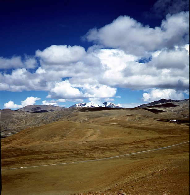
The Tibetan Village Gutsuo lies on an Altitude of 4 400 m
Copyright of Photos: Dr. Klaus Dierks


Tingri Shekar (New Tingri or Shekar Dzong (Fortress)) lies on an
Altitude of 4 300 m. It was the Point of Exit for the British Mount Everest Expeditions
between the two World Wars
Copyright of Photos: Dr. Klaus Dierks


Between Tingri Shekar and the Everest Base Camp south of Rongbuk
lies the Pang La (5 200 m). The Photos show the Villages on the North and South Side of
the Pass and the View from the Pass goes to the North (left Photo) and to the South (right
Photo) to the High Himalayas with Chomolungma (Mount Everest) 8 850 m and Cho Oyu 8 201 m
Copyright of Photos: Dr. Klaus Dierks


The Village Passum lies on an Altitude of 4 504 m and
is situated between the Pangla La and Rongbuk
Copyright of Photos: Dr. Klaus Dierks


The Buddhist Gompa (Monastery) of Rongbuk lies on an Altitude of
5 030 m at the Foot of the North Face of Chomolungma (Mount Everest). The
Gompa was destrotyed during the Chinese Cultural Revolution in the 1960s but has been
reconstructed in the Mean Time
Copyright of Photos: Dr. Klaus Dierks


The North Face of Chomolungma (Mount Everest) 8 850 m from
Rongbuk Base Camp 5 220m. The right Photo shows the Pass Lho La between Tibet and Nepal
(Khumbu) with Pumori 7 161 m on the Right Hand Side
Copyright of Photos: Dr. Klaus Dierks
![]()


The North West Face of Chomolungma (Mount Everest) from the
Kalar Pattar 5 600 m in the Khumbu in Nepal: Left Photo taken in 1980 and the South Face
of Chomolungma from the Mera La 5 415 m in the Hongu (Nepal): Right Photo taken in 1982
Copyright of Photos: Dr. Klaus Dierks
![]()

Copyright: Edward Stanford Ltd. 1992
Second Part of our Tibet Expedition'1997 from Tingri Shekar via the Lhakpa La 5 220 m to Lhaze 4 050 m and further to Sakya 4 280 m and from there via the "closed" Territory along the Sikkim Border to Gala and then to Gyantse 3 950 m and further to Shigatse 3 900 m : The "closed" Territory strechted from Sakya via Dingyyę, Kutschi, Rongxar, Langma, Mukub Gompa, Ne Gompa, Khampa Dzong to Gala

The Lhakpa La (Jia Tsuo La) 5 220 m is situated between Tingri
Shekar and Lhaze
Copyright of Photos: Dr. Klaus Dierks

View from the Lhakpa La to the Chomolungma (Mount Everest) 8 850
m in the South West
Copyright of Photo: Dr. Klaus Dierks

View from the Lhakpa La to the Cho Oyu 8 210 m in the South West
Copyright of Photo: Dr. Klaus Dierks


The Tibetan-Buddhist Monastry Town of Sakya is
the Centre of the Sakya-Pa. The Sakya-Pa was founded 1073 by Konchog
Gyalpo (1034-1102), a disciple of Drogmi. Sakya-Pa was
established under Mongol Protection. Sakya-Pa favours the Teachings of the Indian Adept
Virűpa. Sakya was partly destroyed during the Chinese Cultural Revolution
in the 1960s, but has been reconstructed in the Mean Time. From Sakyo we are travelling
into "Forbidden Territory" close to the Sikkim Border.
Copyright of Photos: Dr. Klaus Dierks
![]()
The "Forbidden" Zone of Tibet along the Sikkim Border

View from the Sebu La 5 430 m to the Kangchendzoenga 8 586 m in
the South in Sikkim
Copyright of Photo: Dr. Klaus Dierks

South of the Sebu La We reach the Upper Part of the Arun River
(Phung Chu) which flows into Nepal (Hongu)
Copyright of Photo: Dr. Klaus Dierks

A Lake east of Dingyyę 4 260 m on Route to Rongxar: View to the
East
Copyright of Photo: Dr. Klaus Dierks


The Village Kutschi 4 630 m south of Dingyyę
Copyright of Photos: Dr. Klaus Dierks

View to the Nyonnori 6 6663 m at the Nepalese Border south of
Rongxar
Copyright of Photo: Dr. Klaus Dierks


Rongxar 4 270 m at the Corner of three Countries: Tibet, Nepal
and Sikkim: The Gompa and the Dzong (Fortress) were destroyed in the Chinese Cultural
Revolution in the 1960s and not reconstructed yet
Copyright of Photos: Dr. Klaus Dierks

View back to Rongxar to the West into Nepal
Copyright of Photo: Dr. Klaus Dierks


View back to Rongxar to the West into Nepal
Copyright of Photos: Dr. Klaus Dierks


The Village Langma, approximately 20 km east of Rongxar: View to
the Sikkim Border and the High Himalaya in the South which I crossed with the Tibetan
Kampa Nomads in 1959
Copyright of Photos: Dr. Klaus Dierks

The Village Langma: View to the North
Copyright of Photo: Dr. Klaus Dierks

Mukub Gompa is situated approximately 50 km east of Rongxar:
View to the East
Copyright of Photo: Dr. Klaus Dierks

In Mukub Gompa we lost our Trail to Kampa Dzong and went into a
northerly Direction to Dobzha: View to the East in Direction Ne Gompa and Kampa Dzong
Copyright of Photo: Dr. Klaus Dierks

View from Dobzha to the South in Direction Mukub Gompa and the
Sikkim Border at the Main Range of the High Himalaya: The Indian Summer Monsoon reaches
the High Himalayas
Copyright of Photo: Dr. Klaus Dierks

Ne Gompa is situated approximately 100 km east of Rongxar: View
to the South in Direction Sikkim Border at the Main Range of the High Himalaya
Copyright of Photo: Dr. Klaus Dierks

Ne Gompa
Copyright of Photo: Dr. Klaus Dierks

View from Ne Gompa to the South East to the Chomo Yummo 6 829 m
at the Tibet - Sikkim Border
Copyright of Photo: Dr. Klaus Dierks

Kampa Dzong (Gamba): View to the South East to the Chomo Yummo 6
829 m and more Himalaya Peaks which are more than 7 000 m high at the Tibet - Sikkim
Border: The Dzong (Fortress) was destroyed during the Chinese Cultural Revolution in the
1960s and is not reconstructed yet
Copyright of Photo: Dr. Klaus Dierks


Unnamed Pass 5 378 m between Kampa Dzong and Tatsang (Takexum):
View to the South to the unnamed and unclimbed 6 000 and 7 000 m high Peaks along the
Tibetan-Sikkim and the Tibetan-Bhutan Border
Copyright of Photos: Dr. Klaus Dierks


Nomads near Tatsang between Kampa Dzong and Gala (Gazla)
Copyright of Photos: Dr. Klaus Dierks

Unnamed Pass 5 260 m between Tatsang and Gala: View to the East
to the 6 000 and 7 000 m high Peaks along the Tibetan-Bhutan Border
Copyright of Photo: Dr. Klaus Dierks

At Guru we are meeting the (still closed) India-Tibet Highway
from Sikkim (Gangtok) to Lhasa through the Tschumbi Valley: In the Background is the Lake
Bam Tso at the Tibetan-Bhutan Border
Copyright of Photo: Dr. Klaus Dierks


Bam Tso at the Tibetan-Bhutan Border with the 6 000 m and 7000 m
high Peaks at the Bhutan Border and in the Interior of Bhutan
Copyright of Photos: Dr. Klaus Dierks
![]()

Copyright: Lonely Planet Publications, 3rd Edition, 1995

Gyantse (3 950 m), 254 km southwest of Lhasa, is one of the least Chinese-influenced Towns
in Tibet: View from the Gyantse Dzong (Fortress: built in the 14th Century) into the Nyang
Chu Valley to the West: In the Plains the British-Tibetan Battle (Francis Younghusband
Expedition) took Place in 1904. The Tibetans tried to defend Gyantse Dzong, but the Fall
of the Dzong was the last Straw in the Tibetan Attempt to repel the British Incursion into
Tibet: In the Middle the Gyantse Kumbum Tschörte (Stupa) to the left and the Main
Monastry Pelkor Chöde to the right
Copyright of Photo: Dr. Klaus Dierks

Main Street in Gyantse with the Dzong in the Background
Copyright of Photo: Dr. Klaus Dierks


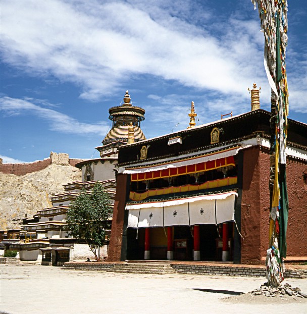
The Gyantse Kumbum to the left and the Main Monastry Pelkor
Chöde (Gelug-Pa Sect) to the right
Copyright of Photos: Dr. Klaus Dierks


The Gyantse Kumbum was built in 1440: The Stupa rises over four
symmetrical Floors and is surmounted by a golden Dome that rises like a Crown over the
four sets of Buddha's Eyes that gaze serenly out in the cardinal Directions of the Compass
Copyright of Photos: Dr. Klaus Dierks

The Gyantse Kumbum: Buddha Sakyamuni Chapel
Copyright of Photo: Dr. Klaus Dierks

The Pelkor Chöde Monastery was founded first in 1418
Copyright of Photo: Dr. Klaus Dierks

View from the Pelkor Chöde Monastery to the Town and Gyantse
Dzong in the Background
Copyright of Photo: Dr. Klaus Dierks

Copyright: Lonely Planet Publications, 3rd Edition, 1995

Shigatse (3 900 m), 70 km northwest of Gyantse, is the second
largest Town in Tibet and the traditional Capital of the Tibetan Province of Tsang.
Shigatse has for Centuries been an important Trading Town and Administrative Centre. The
Tsang Kings exercised their Power from the once imposing Heights of the Shigatse Dzong -
now destroyed during the Chinese Cultural Revolution in the 1960s. Since the Ascendancy of
the Gelug-Pa Order in the 15th Century with Mongol Assistance, Shigatse has been the Seat
of the Panchen Lama, who traditionally is based in the Tashilhunpo Gompa (Monastery)
Copyright of Photo: Dr. Klaus Dierks


Copyright of Photos: Dr. Klaus Dierks
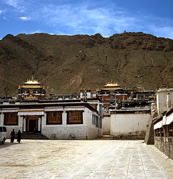
Tashilhunpo Gompa, Seat of the Panchen Lama, is associated with
the Gelug-Pa Order and is one of the six great Gelug-Pa Institutions along with Drepung,
Sera and Ganden in Lhasa and Kumbum and Labrang in Amdo. During
the 14th and 15th centuries Tsong Kha-pa (Lobsang Drakpa or Jé
Rimpoche)(1357-1419), believed to be an Incarnation of the Bodhisattva Manjushri
(Buddha of Wisdom). He reformed the Tibetan Buddhism by the Creation of a new Religious
Order: Gelug-Pa (Yellow Hat Sect). He originated from the Lake Kokonor in
north-eastern Tibet. Originally he favoured the Kadam-Pa School. He
founded the three "Pillars of Buddhism", the three monasteries near Lhasa:
Ganden (1409), Drepung (1416) and Sera
(1419) (Drasang: monastic universities). Tsong Kha-pa also established
the Great Prayer Festival (Mönlam Chemno) after New Year (Lossar). He confirmed Atisha's
stress upon Monastic Virtues and the Need to establish a firm Basis in the Sűtras before
graduating to the Tantras. He followed the Teachings of the great Indian Teachers Nâgârjuna,
Asanga and Dignâga.Tashilhunpo Gompa was
founded in 1447 by a Disciple of Tsong Kha-pa, Genden Drup who became post-hum the First
Dalai Lama.
Copyright of Photos: Dr. Klaus Dierks
Tashilhunpo Gompa: View from the Entrance to the Maitreya Temple
(left) and the Tomb of the 4th Panchen Lama (right)
Copyright of Photo: Dr. Klaus Dierks

Tashilhunpo Gompa: Dharma Çakra (Buddhist Wheel of Life) in the
Entrance Hall to the Main Yard of the Monastery
Copyright of Photo: Dr. Klaus Dierks

Tashilhunpo Gompa: Access Way along the Palace of the Panchen
Lamas with the Kalsang Temple in the Background
Copyright of Photo: Dr. Klaus Dierks

Tashilhunpo Gompa: View from the Court Yard to the Assembly Hall
and the Tomb of the 4th Panchen Lama in the Background
Copyright of Photo: Dr. Klaus Dierks

Tashilhunpo Gompa: Tomb of the 4th Panchen Lama
Copyright of Photo: Dr. Klaus Dierks

View from theTashilhunpo Gompa to the West
Copyright of Photo: Dr. Klaus Dierks
![]()

Copyright: Edward Stanford Ltd. 1992
Third Part of our Tibet Expedition'1997 from Shigatse via the Karo La 5 010 m to the Yamdrok Tso 4 482 m (Scorpion Lake). From there via Nagarze 4 500 m and the Kamba La 4 794 m to the Yarlung Tsangpo (Upper Part of the Brahmaputra) and to Tsetang (Zetong) 3 400 m and the Yumbu Lhakang, the oldest Building in Tibet, from the Period of King Srong tsen Gampo, and to Chenggye to the Tibetan Tombs of the early Yarlung Kings. The Expedition ends at Lhasa, the Capital of Tibet.

The Road from Gyantse to the Yamdruk Tso with the Nozin Kang sa
7 223 m in the Background
Copyright of Photo: Dr. Klaus Dierks


Karo La 5 010m with the Nozin Kang sa 7 223 m in the Background
Copyright of Photos: Dr. Klaus Dierks


Nozin Kang sa 7 223 m
Copyright of Photos: Dr. Klaus Dierks


Yamdrok Tso (Yamtso Yumko) 4 482 m: The Scorpion Lake
Copyright of Photos: Dr. Klaus Dierks

View from the Kamba La 4 794 m into the Yarlung Tsangpo Valley,
near to the Point where the Kyi Chu (Lhasa River) joins the Tsangpo River (Chüsül)
Copyright of Photo: Dr. Klaus Dierks

The Yarlung Tsangpo near Samye (on the opposite Side), Tibet's
oldest Gompa, founded by King Trisong Detsen around 765 to 780
Copyright of Photo: Dr. Klaus Dierks


Yumbu Lakang in the Yarlung Valley is supposed to be Tibet's
oldest Building: The Foundations might go back to 2 000 Years ago: The original Building
was destroyed in the Chinese Cultural Revolution in the 1960s, but it was re-constructed
in 1982
Copyright of Photos: Dr. Klaus Dierks

View from the Top of Yumbu Lakang into the Yarlung and the
Tsangpo Valleys in the North in Direction Tsetang
Copyright of Photo: Dr. Klaus Dierks

View from the Top of Yumbu Lakang into the Yarlung Valley to the
South
Copyright of Photo: Dr. Klaus Dierks

Chenggye: View from the Tombs of the Kings of the Pre-Buddhist
Bön Culture to the North to Chenggye and the Chingwa Tagtsde Dzong (Fortress) at Chenggye
Copyright of Photo: Dr. Klaus Dierks

The Kyi Chu (Lhasa River) between Chüsül and Lhasa
Copyright of Photo: Dr. Klaus Dierks
![]()

Copyright: Edward Stanford Ltd. 1992

Lhasa is Tibet's Capital and the Capital of the eastern-central
Province Ü. Lhasa is the Heart and Soul of Tibet, Abode of the (exiled) Dalai Lama and is
an Object of devout Tibetan-Buddhist Pilgrimage. Lhasa rose to Prominence as an important
Centre of administrative Power in the 7th Century AD, when Srong tsen Gampo (618-649), a
local Ruler in the Yarlung Valley conitnued the Task initiated by his Father of unifying
Tibet. Srong tsen Gampo moved his Capital to Lhasa and built a Palace on the Site that is
now occupied by the Potala Palace (seen on the Photo).
Copyright of Photo: Dr. Klaus Dierks


Lhasa's Heart in the old Tibetan Part of the Town is the
Jokhang Temple. The Barkhor is Lhasa's intermediate Circumambulation Route, a Quadrangle
of Streets that surrounds the Jokhang
Copyright of Photos: Dr. Klaus Dierks


Copyright of Photos: Dr. Klaus Dierks

Copyright: Lonely Planet Publications, 3rd Edition, 1995
The Jokhang Temple (Tsuglagkhang) is the most revered religious Structure in Tibet. The estimated Date for the Jhokang's Founding range from 639 to 647 AD. Construction was initiated by Srong tsen Gampo to house a Buddha Image (Akshobya) brought to Tibet by his Nepalese Wife Princess Bhrikuti. At the same Time, Ramoche Temple was also constructed to house another Buddha Image (Jowo Sakyamuni) brought to Tibet by his Chinese Wife Princess Wencheng. After the Death of Srong tsen Gampo, Jowo Sakyamuni was moved from Ramoche and hidden in the Jokhang by Wencheng, who feared a Chinese Invasion: Photos: Forecourt in Front of the Jokhang

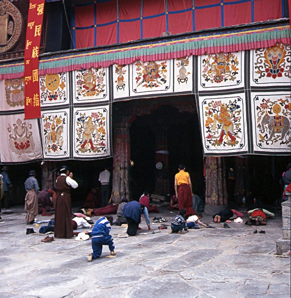
Devout Tibetan Pilgrims entering the Jokhang
Copyright of Photos: Dr. Klaus Dierks

Devout Tibetan Pilgrims before the Buddha Image of Jowo Sakyamuni in the Jokhang
Copyright of Photo: Dr. Klaus Dierks


Images from the Roof of the Jokhang with Potala Palace in the
Background
Copyright of Photos: Dr. Klaus Dierks


The Potala Palace from the South, from Chagpo Ri (Tibetan
Medical College, established by the Great 5th Dalai Lama: destroyed in the Chinese
Cultural Revolution in the 1960s)
Copyright of Photos: Dr. Klaus Dierks


The Potala Palace is situated on Marpo Ri, the 130 m "Red
Hill", where Srong tsen Gampo erected the first Potala Palace in the 7th Century. The
most Buildings of the Potala Palace were erected by the 5th Dalai Lama, Lobsang Gyatso,
when he decided to move the Seat of the Gelug-Pa Government from Drepung to Lhasa. Work
began on the Potrang Karpo (White Palace) in 1645. The Nine-Storey Structure was completed
in 1649 and the Potrang Marpi (Red Palace) was only completed in 1694, after the Death of
the 5th Dalai Lama in 1682
Copyright of Photos: Dr. Klaus Dierks

About eight km to the West of Central Lhasa lies Drepung, once
the World's largest Monastery, with a Population of around 10 000 Monks, one of the three
"Pillars of Buddhism" (together with the Monasteries Sera and Ganden). It has
suffered through the Ages with Assaults by the Kings of Tsang and the Mongols, but it was
left unscathed during the Chinese Cultural Revolution. Drepung was founded in 1416 by a
Disciple of Tsong Kha-pa, Jamyang Chöje. In 1530 the 2nd Dalai Lama established the
Ganden Palace, which was Home to the Dalai Lamas until the 5th Dalai Lama built Potala
Palace in Lhasa
Copyright of Photo: Dr. Klaus Dierks

Mani Stones with a Image of Tsong Kha-pa who established the Gelug-Pa (Yellow Hat Sect)
in the 15th Century


Main Buildings in the Drepung Monastery
Copyright of Photos: Dr. Klaus Dierks

Maitreya (Dschampa), Buddha of the Future in the
Drepung Monastery
Copyright of Photo: Dr. Klaus Dierks


Sera, the "Second Pillar of Buddhism"
was founded in 1419 by a Disciple of Tsong Kha-pa, Sakya Yeshe. It lies
around five km north of Lhasa. It once had a Monk Population of 5 000, to-day a Couple of
Hundred remain. Sera survived the Ravages of the Chinese Cultural Revolution
Copyright of Photos: Dr. Klaus Dierks

View on Sera Monastery and Lhasa with the Potala Palace in the
South
Copyright of Photo: Dr. Klaus Dierks

Maitreya (Dschampa), Buddha of the Future in the
Sera Monastery
Copyright of Photo: Dr. Klaus Dierks

Ganden (4 500 m) the "Third Pillar of
Buddhism" was founded in 1417 by Tsong Kha-pa, the Founder of the
Gelug-Pa Sect. It was completely destroyed during the Chinese Cultural Revolution in the
1960s, but has been re-built since then
Copyright of Photo: Dr. Klaus Dierks

View on the Golden Tomb of Tsong Kha-pa at Ganden
Copyright of Photo: Dr. Klaus Dierks

The Tomb of Tsong Kha-pa at Ganden
Copyright of Photo: Dr. Klaus Dierks
![]()
![]()