1793 The Dutch vessel "Meermin", under Captain Duminy, proclaims sovereignty over Angra Pequeña, Halifax Island and Walvis Bay (26.02.). This expedition, which also explores the Swakop River valley from the coast, is accompanied by the brothers Sebastiaan Valentijn and Dirk van Reenen as well as Pieter Pienaar. The journey leaves Cape Town on 03.01., reaches Angra Pequeña on 13.01., Walvis Bay on 23.01. and returns to Cape Town on 10.04.1793. There are again reports about copper mines south east of Walvis Bay and copper processing by the Dama. On 27.02. there is a violent clash between the local Nama community and the Europeans.
Klaas Afrikaner conducts a commando campaign against the Nama and reaches 
#Nu#goaes (Swartmodder, present-day Keetmanshoop). The "white" farmer Guilliam Visagie defeats the Orlam Afrikaner (Orlams in Nama: !Gû-!gôun or Nauba-xu gye |ki-khoen) and Titus Afrikaner escapes at the last moment.
1795 The British vessel "Star", under Captain T Alexander, takes all potential harbour sites up to 15° south (Namibe/Angola) into possession for the British Crown.
Moses Witbooi is born in Pella (?) in South Africa.
1796-1798 After the shooting of the Dutch farmer Pieter Pienaar (1796) the Orlam Afrikaners leave South Africa permanently and begin to settle in present-day Namibia. They erect the fortified settlement of ||Khauxa!nas. This unique site is the first systematically-built settlement in the engineering sense, and it reflects the evolutionary potential of the Nama community at a crucial moment in history – immediately prior to the rise of armed resistance against colonial rule. The stone-walled settlement is discovered in 1986 by Klaus Dierks.
1797/98 John Barrow reports about copper mining activities by the Dama.
1798-1811 Five unsuccessful pursuit actions are mounted against the Orlam Afrikaners by the Cape Colony authorities.

Karasberge_Ost.jpg (35290 bytes)

The Great Karas Mountains from the East: Landscape of ||Khauxa!nas: Oldest Ruined Settlement in an Engineering Sense in Namibia
Copyright of Photo: Dr. Klaus Dierks

Khauxanas1.jpg (24389 bytes)Khauxanas_View to SE_2001.jpg (19595 bytes)Namibia_Karas_Khauxanas_Ruins_East_1.JPG (88011 bytes)Namibia_Karas_Khauxanas_Ruins_East_2.JPG (107542 bytes)

||Khauxa!nas: General View from West: With Protection Wall in the Background
Copyright of Photos: Dr. Klaus Dierks

Khauxanasmap1.gif (233268 bytes)

Map of southern Africa (1790-1830). It shows: the expansion of the South African Cape Colony and the expanding African states seeking to control land and trade and defend themselves from Boer, Orlam and other African raiders. The block shows the next map with ||Khauxa!nas and Narudas (Robber Henrick's Place)
Longman Namibia: Anne Westoby

Khauxanasmap2.gif (122484 bytes)

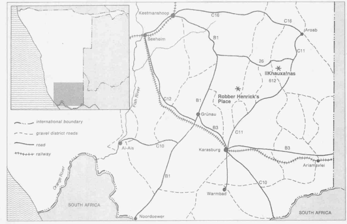
Southern Namibia with ||Khauxa!nas and Narudas (Robber Henrick's Place)
Longman Namibia: Anne Westoby

Namibia_Karas_Warmbad_OldPastorie_1.JPG (92594 bytes)

The old "Pastorie" of Warmbad which is built on the Foundations of the House which was established by the London Missionary Society Brothers Abraham and Christian Albrecht in 1805
Copyright of Photo: Dr. Klaus Dierks

WB00823_.GIF (134 bytes)

[Return to Table of Contents]

forward.GIF (132 bytes)