

T
he starting point for the rediscovery of ||Khauxa!nas was the information contained in the diaries and memoranda of the two Wesleyan missionaries - Benjamin Ridsdale and his successor John A. Bailie [1]. Both were from the Wesleyan Missionary Society and became missionaries in Warmbad during the 1840's. Ridsdale recorded a precise description of this major historical site; significantly his mid-century description appears to be the only one of its kind. None of the written accounts of the Orlam Afrikaners' history, nor the records compiled by the Rhenish Missionary Society, mention this ruined settlement. Apart from Ridsdale's account we have no written records and have to rely on archaeological methods (or better, evidence).
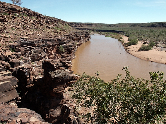
Overview of the
||Khauxa!nas Mountain
Copyright of Photos: Dr. Klaus Dierks
But, how could it happen that such a unique place had been forgotten about since Ridsdale's days and its historical significance only quite recently re-established? Was it that the people of this region of south eastern Namibia were afraid of evil spirits haunting the ancient ruins? Or could it be rather that the Nama people of this area had good reasons of their own for maintaining the secret of the fortifications? Of course, the impressive ruins were known to the local inhabitants and some others, but the true historical classification of the site and its significance to Namibia's history has only now emerged.

The view to the Southeast
Copyright of Photo: Dr. Klaus Dierks

||Khauxa!nas from the West in the Direction of the Pprotective
Wall
Copyright of Photo: Dr. Klaus Dierks
This is by no means the first instance of ruins being known about without their true significance being appreciated. To take an example from classical history; the ruins of the city of Troy were of course known to the Anatolian farmers and even to some European academics, but it was not until the efforts of Heinrich Schliemann that the true import of this site for ancient Greek history was established. Schliemann's great contribution was that he believed in the historical authenticity of Homer's Iliad. The same approach can be applied to the rediscovery of ||Khauxa!nas because I believe in the authenticity of Ridsdale's records. But, can Ridsdale's diaries be trusted? I would submit, that like many other missionaries and naturalists - for example, Campbell, Moffat, Holub and others - Benjamin Ridsdale can surely be credited when he describes ruins, in contrast to many "traveller's tales" whose accounts should be treated with caution.

||Khauxa!nas Ruins: View to the East
Copyright of Photo: Dr. Klaus Dierks
During my research work into the old road systems of this country, I discovered evidence of the remarkable road building activities of the Nama in southern and central Namibia during the 19th century. Many examples of road construction during the first half of the 19th century took place in the south. These and other activities by the Nama people show the widespread belief that only Europeans built roads in Namibia to be a myth [2]. One of my primary historical sources contains the following evidence of pre-colonial road construction works. In December 1846, Benjamin Ridsdale recorded the following about the building of roads by the "Veldschoendragers" in the vicinity of Warmbad [3]:
"In several parts of the circuit, also, at great expense of labour, new roads have been made, and old ones shortened and improved. We have exhorted them in prophetic language: "Prepare ye the way of the Lord, make straight in the desert a highway for our God!": and they have done so: parties of road-makers have been formed; no remuneration has been given; but now "the crooked places are made straight, and the rough places plain". One of these "rough places", so rough as to shake waggon and traveller nearly in pieces, was made "plain" by one of our native teachers and all his scholars, who persevered in their voluntary task, casting all the loose stones aside, till a good, broad, and perfectly clear road was thrown open ... By these improvements, the circuit is much diminished in its extent; and we are enabled to reach our most distant outposts with a considerable saving of time, and much more comfort than formerly."
On 3 April 1847 Ridsdale wrote further about the road building activities of the Nama [4]:
"This morning we arrived at Schans Vlakte, a village of the Velschoen Draagers. .. For a considerable distance before reaching the village our attention was arrested by the amount of labour the people had bestowed in road-making. On former occasions I had visited this tribe on horseback; but as they had for some time past expected that I should visit them with the wagon, .., they had with great labour, and no implements more powerful than their hands, torn up enormous stones and made a clear open road for a wagon, of many miles in length. From the wild and rugged nature of this part, there can never be what an Englishman would call a good road: still, this is one that can be travelled without danger, and it reflects great credit on its inexperienced makers."
The goal of the Veldschoendragers' road construction work was the village of Schans Vlakte, which itself appears to have been an exceptional Nama settlement. This unique place is all the more remarkable as one of the best guarded secrets of the people who lived there nearly 200 years ago. Besides the references by Ridsdale and Bailie to Schans Vlakte there are no other historical sources that I am aware of which take note of the settlement. The investigation leads me to the conclusion that Ridsdale's Schans Vlakte is located on the site of the present farm, Schanzen 281, east of the Great Karas Mountains. This assumption was subsequently verified by aerial photographs and on the ground investigations which clearly revealed a ruined town atop a mountain above a river, matching Ridsdale's description exactly. He presents the following evidence about Schans Vlakte and the mountain fortress ||Khauxa!nas, which corresponds to the observable locality [5]:
"... In front of the village is a low mountain, which is surrounded at the top by a wall, the entire length of which must be eight or ten hundred yards, low in places difficult to access, and five or six feet high in those parts that are most easily available. This wall, which consists of a double row of loose flat stones piled one above another, was thrown round the mountain by the Afrikaners (Orlam Afrikaners from Nama descent) at the beginning of the century. After shooting of the Dutch Boer, Pinnar, to whom old Afrikaner and his clan were at that time subject, and by whom they were oppressed beyond all endurance, Afrikaner and his people fled to this place. Here they resolved upon making a stand against the commandoes sent in pursuit of them by the Colonial Government (Cape Colony in South Africa). Within this entrenchment, at the top of the mountain, they built their houses, had kraals for their calves, and in fact everything necessary to a Namaqua village, and considered themselves able to defy all their enemies. They seemed scarcely able to conceive of a valour that would proceed in the face of their bullets, scale their fort, bound over its walls, drive them over the fearful precipice on the opposite side, and plunge them into the abyss of black waters beneath. The opportunity of defending themselves in their impregnable fortification, however, never occurred, as the commandoes of Boers from the Colony pursued them no farther than Nisbett Bath (Warmbad). This entrenchment remains unimpaired to this day, and is at least a proof that the Afrikaners possessed an energy of character much greater than that possessed by the Namaqua tribes generally. I felt much interest in viewing this relict. ... I next inspected the new stone chapel in course of erection. The walls, in nearly their entire length, are raised to the height of six feet, and are two feet thick, and when the building is completed, it will hold about three hundred hearers."

Part of the Wall around ||Khauxa!nas
Copyright of Photo: Dr. Klaus Dierks
This extraordinary description of a pre-European settlement fascinated me. Ridsdale visited Schans Vlakte in April 1847, and, as far as is known, was one of the few Europeans allowed to see this secret Nama refuge predating the arrival of the Germans in Namibia. Yet ||Khauxa!nas was apparently ignored or not known by the historians of that time and later, as it has not been possible to discover one single reference to the site's existence. However, a starting point in the search for the identity of ||Khauxa!nas is provided in the impressive authenticity of Ridsdale's observations. It was my firm belief that a settlement of the size described could not disappear without trace and was to be found somewhere in the south of Namibia.
During 1977-78, when I was involved in the construction of three bridges in the south - over the Kais, Bak and Kainab rivers - I had been told by local farmers about the existence in the area of old fortifications, which they said had a connection with the events of the Nama uprising against the German colonial administration of 1903- 1909 [6].
This information was the first contemporary reference to ||Khauxa!nas.
Ridsdale's account of his journey to the place, the travelling times and directions in his diary, led me to commence the search on the present-day farm Schanzen 281. This name could refer back to Ridsdale's Schans Vlakte, the German translation of which is " Schanzenfläche" (Plain of the Bulwark). His journey by ox-wagon from Warmbad to Schans Vlakte took nine days (from 24 March to 3 April 1847), travelling in a north-easterly direction [7]. If we postulate that the ox-wagon could have covered 18 km per day in the difficult terrain east of the Great Karas Mountains, he could have reached a point on the Schanzen farm [8].
The modern maps 2718 " Grünau" and 2719 AB " Warmfontein" refer only to "Old German Fortifications 1904-1906" on the Gugunas and Schanzen farms. From my personal contacts with the farmers of Schanzen 281, Back River 302 and Gugunas 301 I was able to further narrow down the problem of ||Khauxa!nas' location. A careful study of aerial photographs revealed a fortified, hilltop establishment, situated right on the precipices overlooking the Bak River [9].
This was exactly as described by Ridsdale in 1846-47. It convinced me that I had located Namibia's oldest stone-walled settlement, a Nama stronghold against colonial troops from the Cape Colony.
Further research into the history of ||Khauxa!nas brought more exciting historical facts to light, giving rise to the hypothesis that not only might this ancient ruined settlement be the oldest systematically-planned building structure in Namibia extant. It could also have been designed and constructed by its Nama builders to withstand colonisation from the south, later becoming one of the last hiding places of the Namibian leader Jakob Marengo from the German occupying forces during the war of 1903-09 [10].
Bearing in mind both these historical factors and the recent political events in the country, ||Khauxa!nas could take on a very special meaning for the Namibian people as a symbol of their ultimately successful struggle for independence.
Ridsdale's observations highlight a chapter in the history of the Orlam Afrikaners - their initial collaboration with and subsequent resistance to European settlers in the northern frontier zone of the Cape Colony during the latter years of the 18th century.
The massive expansion of European economic interests in the seventeenth and eighteenth centuries influenced the most remote indigenous communities in Asia and Africa in a so far unknown way resulting in a new single dominant world economy. The effects of this development included the collapse of indigenous economies and extreme social disruption, particularly among communities without centralised political order. In southern Africa this process, outgoing from the newly established Dutch outpost of Cape Town in 1652, resulted in the demise of nomadic pastoralism within 200 years.
As a consequence of these developments some Cape Nama communities had begun to retreat northwards from Cape Town, firstly into the Cape interior and later into what is present-day Namibia. This movement had the effect of extending the power of the European influenced Cape market economy more rapidly than would otherwise been possible. The immigrant Cape Nama communities are commonly described under the collective name of Orlams. The Orlams played a key role in the 17th and 18th century history of southern Namibia. Ownership of guns, horses and ox wagons gave the Orlams a distinct above other pastoral societies in Namibia. However, the extent to which this "Kommando" economy derived from colonial as opposed to indigenous pastoral structures have to be evaluated can still be open to debate. This debate can now take a new course in the light of the discovery of ||Khauxa!nas [11]. The pastoral settlement of ||Khauxa!nas shows evidence of social change, shedding new light on pastoralist response to early colonial contact.
The trenchant resistance of the Orlam Afrikaners to early South African colonisation attempts is of particular relevance to the history of ||Khauxa!nas. One of the chief events of the period was the death of the brother of the probable founder of ||Khauxa!nas, Afrikaner, on Robben Island in 1777, where he had been sentenced to lifelong imprisonment - a close parallel with contemporary history [12]!
But this is not the end of the saga. The last Nama leader who can be linked to ||Khauxa!nas in any way was the Veldschoendrager Chief !Kharab !Hao-khomab or Jan Hendrik, who died in Windhoek prison during 1924. Here too the story of ||Khauxa!nas is a microcosm of Namibia's broader history.
Resistance by the Orlam Afrikaners' culminated in March 1796 with the shooting of a farmer, Pieter Pienaar, who had sailed to Walvis Bay in 1793 as well as exploring the lower Swakop river valley. Subsequently the Orlams retreated to the inaccessible Karas Mountains where they established ||Khauxa!nas as their hidden refuge against further attempts to impose colonial rule from the south [13].
This Nama/Orlam town is most likely to have been constructed shortly before or just after the turn of the century.
But there is evidence that the Orlams had visited southern Namibia as early as the 1770s. This would be the earliest possible date for their foundation of ||Khauxa!nas, or otherwise the point in time when the Orlams first made themselves acquainted with the surrounding region [14].
Subsequent to my initial research it had been established that ||Khauxa!nas could not be the same as "Robber Henrick's Place" which James Edward Alexander tried to reach in January 1837 as previously assumed. New research established that "Robber Henrick's Place" was most likely to comprise the stone ruins located on the top of a steep hill on the farm Narudas 268 at the eastern edge of the Great Karas Mountains. Alexander was, however, not able to visit the capital village of the Veldschoendragers and was only permitted to proceed as far as Kama Kams. This Nama word translates literally as " Green River" and a farm, Groen Rivier 265, is located several miles away from "Robber Henrick's Place" [15]. The latter could also be identical with Ridsdale's " Klip Fontein", the Veldschoen-dragers' capital village during the 1840s [16]. It is unfortunate that Ridsdale's account of his journeys was not accompanied by a map, which would have enabled us to establish with certainty the actual locations of the Veldschoendragers' settlements, "Robber Henrick's Place" or "Klip Fontein" and somewhat to the north-east, ||Khauxa!nas.
The fortified town of ||Khauxa!nas was last used as a refuge for Jakob Marengo during the Nama-German war of 1903-09. Marengo repeatedly used the barren and inaccessible terrain as a safe haven to elude pursuit by the German Schutztruppe. From here he launched a series of surprise attacks on the Germans, defeating them time and again. His secret retreat west of the Schambockberg on the Kais farm (subsequently farm Tränental 299) was most probably ||Khauxa!nas. From here he attacked a German military unit led by Lieutenant Baron Nikolai von Stempel, who was killed on 30 August 1904 on the farm Gugunas 301, only a few kilometres from ||Khauxa!nas. This was the start of the major phase of the war against the German colonial administration. The Germans became so enraged at the unconventional and ingenious methods of warfare employed by Jakob Marengo, that in desperation they executed the three sons of the Gugunas farmer, Alfred Fryer on the farm Garabis on 29 September 1904 [17].
These historical events have been confirmed by surveys of the present farms Schanzen 281, Back River 302 and Gugunas 301, as well as ||Khauxa!nas on the farms Gugunas and Schanzen respectively. What was found precisely rallies with Ridsdale's description of the settlement overlooking the Bak river. This river always contains water, even during periods of drought. Here was discovered - virtually intact - a ring wall over one km long, with the ruins of houses and kraals, as well as foundations of what was most likely a council chamber for Nama leaders. There is also a well-constructed pathway to the hill-top fortress, one of the first man-made transport routes in Namibia [18].

Pathway leading to the Top of the ||Khauxa!nas
Fortress: 1988
Copyright of Photo: Dr. Klaus Dierks

View from the Pathway to the Bak River: 1988
Copyright of Photo Dr. Klaus Dierks

Precolonial Pathway to the Top of the ||Khauxa!nas Ruins: April
2003
Copyright of Photo: Dr. Klaus Dierks

Bak River at ||Khauxa!nas east of the Great Karas Mountains:
April 2003
Copyright of Photo: Dr. Klaus Dierks

||Khauxa!nas: View from the Top of the
Mountain: Onto the Back River: January 2004
Copyright of Photo: Dr. Klaus Dierks


Bak River at ||Khauxa!nas: View from the Pathway to the Top of
the ||Khauxa!nas Ruins: During the Rainy Season 2003/2004: January 2004
Copyright of Photo: Dr. Klaus Dierks

View from the ||Khauxa!nas Fortress to the Bak River (view to
the SE)
Copyright of Photo: Dr. Klaus Dierks
The mountain top, surmounting the almost vertical rock face dropping to the Bak River, is an awe-inspiring sight. The uniqueness of these ruins in Namibia make it a national imperative that they should now be systematically investigated by archaeologists and other life-scientists. Even the remains of a quite remarkable building at the foot of the ||Khauxa!nas mountain are still extant and could be the chapel built by the Veldschoendragers in the 1840s, as described by Ridsdale [19].
The availability of water at all times must have made this place the ideal settlement and refuge for different groups of Namibians over the years.
||Khauxa!nas is approximately 200 years of age, and the available historical evidence indicates it was most probably built between 1770 and 1798, although in archaeological terms it could well prove to be much older. The building material used in its construction is over 500 million years old according to geological classification. The fortress consists entirely of stacked red sandstone rock slabs forming a double wall one to two metres high. The space between the walls is filled with smaller stones and shale, giving a total width of one to one-and-a-half metres.
The flat-sided sandstone slabs are skilfully piled one on top of the other, fitting accurately together. Geologically, these are rocks of the Nama Group (specifically the Breckhorn and Nababis formations of the Fish River Subgroup). The top layers of stones had been in many instances worn by the effects of erosion and possibly animal or human activity in the course of the long history of ||Khauxa!nas. The entire Orlam town on top of ||Khauxa!nas mountain is surrounded by a particularly large, similarly well constructed and impressive stone wall, also up to two metres high and one metre thick, as described by Ridsdale. In its general course, this protective wall forms an irregular ellipse. Hundreds of thousands of rock fragments were used in building this settlement. Apparently the Orlam builders never intended to provide roofing of any kind, although their stonework walls enclosed living, as well as functional space, and kraals. The cumulative impact of thousands of stacked stones is evidence of concerted human effort involving the labour of hundreds, if not thousands of workers over a considerable period.
All of the original Orlam town, encircled by its protective wall, lies on the crest of the ||Khauxa!nas mountain. The Veldschoendrager village which Ridsdale and Bailie saw in the 1840s and which they called Schans Vlakte, is situated at the foot of this mountain. The remains of what may have been the ||Hawoben church mentioned by Ridsdale can still be seen. It is also skilfully built with flat rock slabs, with in places a kind of mortar still intact and clearly visible between the slab layers. There is however disagreement as to whether this is in fact Ridsdale's ||Hawoben church. According to the Gugunas 301 farmer, H.J.K. Smith, this building was an old livestock dip tank. However, it would be surprising if a dip tank had been built in such a grand style as we see it here. It is conceivable that the ||Khauxa!nas ruins were used, like those of so many other sites during history, as mere quarries for building material. At periods in the past when ruins were not protected their well-shaped or hewn stones, kiln-fired bricks or tiles, scattered over the site provided an ideal source of construction material. Many stones from ancient ruins throughout southern Africa have been used for military forts, farms and even dip tanks [20].
Another ruin near the remains of this building is said by the local farmer to be the old "Hottentot Kerk". The actual location of this Veldschoendrager church has yet to be established, and many problems remain to be resolved. However, the weight of available evidence demonstrates that ||Khauxa!nas on the Gugunas 301 and Schanzen 281 farms near district road 612, is the forgotten town of the Orlam Afrikaners, and later the Veldschoendragers, who occupied the settlement after the former had left the Karas Mountains in their northward migration to central Namibia. The boundary fence between these two farms actually crosses the ruins.
The Nama had every good reason, as we have seen, to keep ||Khauxa!nas a secret, especially from Europeans, and this must surely be the reason why no reference to it can be found in any primary historical sources, except those of Ridsdale and Bailie, and mentions made by Alexander. In his fragmented diaries, Jakob Marengo referred to ||Khauxa!nas as "Kactchanas". The area is so inaccessible and was evidently so poorly known to the German colonial administration, that its records contained absolutely no reference to the settlement, so far as it has been possible to determine [21].
After having served the interests of the Nama people for one last time as Jakob Marengo's refuge, ||Khauxa!nas sank into oblivion until its present-day rediscovery. This impressive mountain fortress is situated in one of the most beautiful landscapes of Namibia. After the required archaeological and historical research has been carried out it has the potential of becoming one of Namibia's major tourist attractions. A good description, again is provided by Ridsdale [22]:
"For forty or fifty miles before reaching Schans Vlakte the character of the scenery is totally different from any other in the circuit, or indeed from any other I have seen in South Africa. It is as wild and gloomy as the imagination can conceive. Rugged and barren ravines, skirted with a succession of terrible and abrupt precipices, here and there rent by gloomy fissures, fill the mind of the solitary traveller with an irrepressible feeling of awe. The towering height of these lofty precipices makes the passer-by most impressively to feel his own nothingness in contrast with their mighty magnitude, whilst their grey and age-worn appearance is in perfect keeping with the brown and faded aspect of the trees and shrubs around. Along these ravines an African river invariably courses its way in time of storm, though generally leaving nothing for the eye to gaze upon but its bed of dry and burning sands, with here and there a stagnant pool of black or green water, of unknown depth, deposited at the base of a high and massive precipice.
The age-worn precipices, and the pools of dark water at their base, the withered aspect of the vegetation around, and the black prostrate arms and trunks of trees lying in the most fantastic and serpentine forms, the holes in the face of the rocks suggestive of tigers' dens, and the deathlike stillness only broken by the shrill screams of the wild geese disturbed in their pools, or by the gruff salutation of the baboon as he spies the puny traveller from the top of his rocky heights, invest the entire scene with an air of almost depressing melancholy. One feels as if he were treading regions that had never been trodden by the foot of man before, and can easily imagine them to be the abode of every doleful creature. And if it be the first visit to these dreary scenes, without the rattle of a waggon's wheels or the smack of the driver's huge whip to cheer his spirits and drive away the awful solemnity of the reign of silence, the traveller is almost ready to imagine that at every step he takes some direful monster from the rocks, or holes, or mountains, will stand before his view."
This is a fitting description of the landscape around ||Khauxa!nas and it accurately portrays the feelings of the visitor to the place even in these days of four-wheel-drive vehicles.
In September 1987 preliminary archaeological investigation of ||Khauxa!nas began [23]. It was established that it could even be much older than the Orlam era at the end of the 18th century and that different periods of settlement could be identified.
Ruins dating from the first period (||Khauxa!nas I) could be the mountain top settlement of the same age as other ruins on various hills in the region and the "battlefield ruins" of the Back River 302 farm. These remains are consisting of a few roughly built windbreaks and hut circles associated with short lengths of walling that may have formed part of a livestock enclosure. The buildings can be found in the central part of the walled plateau. The positioning of these features appears also to be defensive showing that pastoralists in this area were subject to raiding even before the eighteenth century [24].
The second period (||Khauxa!nas II) comprises the major walled structures whose building technique shows the 18th century influence on Orlam building style. This typical African structural style, especially the walling technique, can be found at many other similar ruined settlements of southern Africa [25]. The fact that there are no other sites of the ||Khauxa!nas II period in the vicinity probably is a reflection of the Orlam hegemony during this time.
There are several indications that after the ||Khauxa!nas II era the settlement was re-occupied in more recent times. This third period is characterised by some sheep folds or temporary shelters most probably originating in the German and South African colonial eras (||Khauxa!nas III). The Schans Vlakte of the ||Hawoben is situated somewhere between ||Khauxa!nas II and ||Khauxa!nas III.
I would venture to suggest that ||Khauxa!nas could be the well-executed work of an early Namibian pastoral community based on family ownership of different livestock varieties. The independent family units identifiable at the settlement comprise simple huts around more complex central dwelling structures. Each family unit had its own separate entrance structure in the protective wall of ||Khauxa!nas. An especially well-built section of the ring wall on the south-eastern side with relatively few entrances could have acted as a reception area given that this would appear to be the direction from which visitors would have gained access to the settlement. Most of the extant ash heaps are located outside the protective wall, but a few are situated in or near the relatively complex dwellings. These could be a source for additional archaeological research and dating. The only archaeological find of any real significance to date is one interesting glass bead, which seems to be quite unique with none of similar type found elsewhere in Namibia [26].
The name of Gugunas farm itself indicates a relationship with ||Khauxa!nas and according to the Toponymica Hottentotica, Volume A (THA), Gugunas is derived from the name Khouchanas. This name can be found on the map compiled by Theophilus Hahn in 1879 and the German "Kriegskarte" (war map) of 1904. According to the THA ||Khauxa!nas means "full of Swarthaak trees", but the word could also have a totally different meaning. "||Khau" in Nama means "to defend" and thus has a clear connection to one or other type of defensive structure. ||Khauxa!nas in fact could have the same meaning as Schans Vlakte. "Schans" (in Afrikaans "Skans") means a bulwark, fort or entrenchment. The literal translation of Schans Vlakte into Nama is " ||Khaubasen!naPgas" [27]. This translation of the word "||Khau" was given to the author by Reverend Hendrik Witbooi [28], who is the great-grandson of Hendrik Witbooi, the renowned Namibian resistance leader against the Germans during the period from 1890 to 1905. A second reference to the identity of ||Khauxa!nas can once again be found on the 1904 German war map. As well as "Khouchanas" the name " Uimuchanab" is listed. This can have the meaning "where there are rocks", "where there are stones" or alternatively "where there is a shadow". Whatever the arguments over the precise meaning of ||Khauxa!nas, the most exciting aspect of the rediscovery is that one of the pre-colonial Namibian communities should have been capable of building on such a monumental scale.


||Khauxa!nas: Karen (née von Bremen) and Klaus
Dierks (left Photograph with Jakob Marengo's House): January 2004
Copyright of Photos: Dr. Klaus Dierks and Alexander Dierks (left two
phographs)
The discovery of ||Khauxa!nas provides new insights into the social consequences of the transitional period between the pre-colonial and the colonial eras for the Nama. The evidence of ||Khauxa!nas could contradict the general view that the eighteenth century Nama were little more than a colonial underclass. The evidence found in this complex stone-walled settlement point to the rise of a hierarchical organisation uniting autonomous households within a pastoral alliance [29]. This development reflects the evolutionary potential of the Nama society at a crucial moment in its history, immediately prior to the rise of armed resistance struggle of the Namibian communities against various colonial authorities.
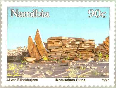


NamPost stamps on the ||Khauxa!nas ruins, 06.02.1997
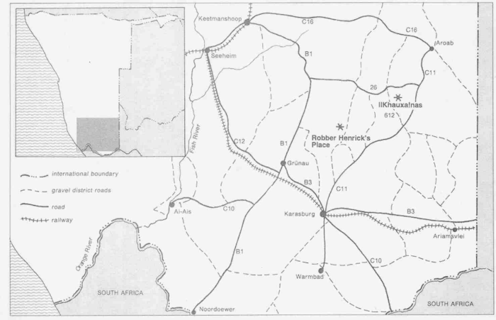
Southern Namibia with ||Khauxa!nas and Narudas (Robber
Henrick's Place)
Anne Westoby, Longman Namibia
Notes
[1] Dierks: ||Khauxa!nas, op cit, p.2
[2] Dierks, Klaus: Namibian Roads in History: From the 13th Century till Today, Frankfurt, 1992, p.18 onwards
[3] Wesleyan Missionary Notices: Vol.5: 1847: Great Namaqualand: Extract of a letter from the Reverend Benjamin Ridsdale, dated Nisbett Bath, 12 December 1846, Cory Library, Grahamstown
[4] Ridsdale, Benjamin: Scenes and Adventures in Great Namaqualand, T. Woolmer, London, 1883, p.274 and Lau, Brigitte: The Emergence of Kommando Politics in Namaland, Southern Namibia, 1800-1870, M.-A.-Thesis, University of Cape Town, 1982, p.170. Other references to ||Khauxa!nas exist in: Mears, W. G. A.: Wesleyan Missionaries in Great Namaqualand, 1820-1867, Cape Town, 1968, p.20-23 and in John A. Bailie's diary, 1845-1850, in the Dutch Reformed Church Archives, Cape Town
[5] Ridsdale, op cit, p.275-276
[6] The national resistance war of the Nama community against the German
colonial power lasted from 1903 to 1909, although ||Khauxa!nas was involved only until
around April 1906 when Jakob Marengo left the region east of the Great Karas Mountains to
continue the struggle elsewhere and possibly in September of that year when it could have
provided a refuge for the Nama leader Johannes Christian. The war continued until February
1909 when Simon Koper agreed never to enter "Deutsch Südwest-Afrika" again.
Simon Koper would most probably have known about ||Khauxa!nas. Oral testimony collected in
the area revealed that old Nama people refer to the "Schanzen" as a relic of the
resistance war against the Germans. Earlier reminiscences were not recorded and have thus
been lost.
See also: von Estorff, Ludwig: Wanderungen und Kämpfe in Südwestafrika, 1894-1910, John
Meinert, Windhoek, 1979, p.147 in which von Estorff writes that during 1909 supporters of
Jakob Marengo in the Great Karas Mountains resumed fighting against the Germans, which led
to demands for the construction of the railway between Keetmanshoop and Windhoek during
debates in the German "Reichstag".
See also: Helbig, Ludwig and Helga: Mythos-Deutsch-Südwest: Namibia und die Deutschen,
Beltz, Weinheim and Basel, 1983, p.139-168 and Schmiedel, Hans: Hauptmann Friedrich von
Erckert in Deutschsüdwestafrika und seine Zeit, Selbstverlag, Ansbach, 1974, p.171 in
which it is stated that supporters of Simon Koper continued resistance against the Germans
until August 1913 (Leutnant Kirchheim: September 1912 and August 1913).
[7] Ridsdale, op cit, p.271-273
[8] Dierks, Klaus: Namibian Roads in History, From the 13th Century till Today, Frankfurt, 1992, p.36-37
[9] Bak River in Afrikaans means "Trough River" and is the literal translation of the Nama word Pgoub (Toponymica Hottentotica, Volume A: THA).
[10] Many historians are still incorrectly using the name Morenga
instead of Marengo. All contemporary documents, excepting German colonial and military
sources, refer to the Nama leader in the 1903-09 resistance war as Jakob Marengo, or
sometimes Jakob Maringu, Marengu, Marenga or Marenka. Marengo's second youngest son,
Charlie, called himself Marengo. Charlie Marengo died on 28 August 1989 in Kakamas/South
Africa and was buried on 9 September 1989 at Vaalgras in Namibia.
See: Zaby, A.: Die Riemvasmaker: Geschichte und Kultur einer Gemeinschaft, Namibiana, Vol
IV(1), SWA Scientific Society, Windhoek, 1982, p.16 and 29. See also: Tuche, Paul: Als
Veterinär im Lager des Feindes, Mitteilungsblatt des Traditionsverbandes für ehemalige
Überseetruppen, 40/41, p.8
[11] Kinahan, John: The Archaeology of Social Rank Among Eighteenth-Century Nomadic Pastoralists in Southern Namibia, 1996, p. 226, 230
[12] Resolutions, September 1761, C 139, Cape Archives, p.420-421. See also: du Bruyn, Johannes: Oorlam Afrikaners: From Dependence to Dominance, ca 1760-1823, unpublished paper, Pretoria, 1981, p.3
[13] Franken, J. M. L.: Duminy Diaries (P. Pienaar: 1793), The Van Riebeeck Society, Cape Town, 1938, p.284
[14] Gordon's letters and diaries: Gordon's Journal II: 8.-12.12.1779, VC 593, Cape Archives
[15] Dierks: ||Khauxa!nas, op cit, p.21 and Alexander, James, Edward.: Expedition of Discovery into the Interior of Africa, vol.1, 1838, Reprint: Struik, Cape Town, 1967, p.208-210
[16] Ridsdale, op cit, p.165-171
[17] Official correspondence in the records of German South West Africa in the State Archives in Windhoek
[18] This pathway was identified by J. Kinahan during his preliminary archaeological investigations in 1987.
[19] Ridsdale, op cit, p.276
[20] Summers, op cit, p.xv
[21] Die Kämpfe der deutschen Truppen in Südwestafrika (Generalstab), Vol.2, Ernst Siegfried Mittler und Sohn, Berlin, 1907, p.72 and Von Dincklage-Campe, Friedrich: Deutsche Reiter in Südwest, Deutsches Verlagshaus Bong & Co., Berlin, Leipzig, Wien, Stuttgart, 1908, p.152-154
[22] Ridsdale, op cit, p.278-279
[23] Oral information from J. Kinahan of the Namibian State Museum in Windhoek who began preliminary archaeological research on ||Khauxa!nas in 1987.
[24] Kinahan, John: The Archaeology of Social Rank Among Eighteenth-Century Nomadic Pastoralists in Southern Namibia, 1996, p.234
[25] O'C. Maggs, T. M.: Iron Age Communities of the Southern Highveld, Pietermaritzburg, 1976, p.51. This structural method was followed by many ancient cultures in the Middle East, for instance during the old Hittite and Hittite imperial periods between 1750 and 1200 B.C. in Hattusa and Alaça Höyük in Central Anatolia.
[26] Oral information from J. Kinahan
[27] Oral information from E. Eiseb and W.H.G. Haacke
[28] Minister of Human Resources and Labour of the Republic of Namibia since independence and Deputy Prime Minister since March 21st, 1995
[29] Kinahan, John: The Archaeology of Social Rank Among Eighteenth-Century Nomadic Pastoralists in Southern Namibia, 1996, p.225
[ Table of Content ] |
|